
Klietz topographic map
Interactive map
Click on the map to display elevation.
About this map
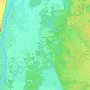
Name: Klietz topographic map, elevation, terrain.
Average elevation: 36 m
Minimum elevation: 24 m
Maximum elevation: 61 m
Aland | Altmärkische Höhe | Altmärkische Wische | Arneburg | Bismark (Altmark) | Eichstedt (Altmark) | Goldbeck | Hassel | Havelberg | Hohenberg-Krusemark | Iden | Kamern | Klietz | Osterburg (Altmark) | Rochau | Sandau (Elbe) | Schollene | Schönhausen (Elbe) | Seehausen (Altmark) | Stendal | Tangerhütte | Tangermünde | Werben (Elbe) | Wust-Fischbeck | Zehrental