
Make a donation
Inuvik topographic map
Click on the map to display elevation.
Make a donation
About this map
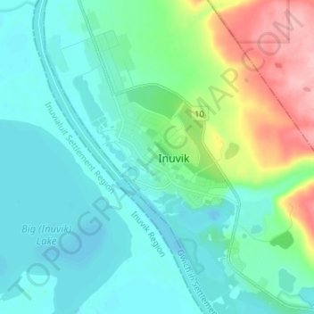
Name: Inuvik topographic map, elevation, terrain.
Location: Inuvik, Northwest Territories, X0E 0T0, Canada (68.33678 -133.77296 68.38401 -133.67031)
Average elevation: 29 m
Minimum elevation: -2 m
Maximum elevation: 130 m
Make a donation
Other topographic maps
Click on a map to view its topography, its elevation and its terrain.
Mackenzie River
Canada > Northwest Territories > Dehcho Region
The Mackenzie widens considerably to about 6 to 7 km (3.7 to 4.3 mi) at Norman Wells, a major center of oil production. There is a narrows at the Mountain River confluence called the Sans Sault Rapids, where the Mackenzie falls about 6 metres (20 ft). Below the Mountain River the Mackenzie flows due north…
Average elevation: 338 m
Make a donation
Make a donation
Behchokǫ̀
Canada > Northwest Territories > North Slave Region > Behchokǫ̀
As the community grew alongside increased services such as a mission-run hospital and church, the government viewed the topography of Fort Rae as unsuitable for expansion. In the 1950s there was concern about runoff from animal and human wastes contaminating sources of drinking water, and the government…
Average elevation: 166 m
Make a donation
Nahanni National Park Reserve of Canada
Canada > Northwest Territories > Dehcho Region
Average elevation: 1,145 m
Make a donation