
Make a donation
Cuyo topographic map
Click on the map to display elevation.
Make a donation
Cuyo
Cuyo Island is the largest island of the Cuyo Archipelago, about 13 kilometres (8.1 mi) long, 7.5 kilometres (4.7 mi) wide, and with an area of 57 square kilometres (22 sq mi). Mount Bonbon with an elevation of 817 ft (249 m) is the highest mountain in Cuyo island. The Island is under the jurisdiction of the municipalities of Cuyo and Magsaysay. The poblacion of Cuyo is home to a Spanish fort, which shelters a church and a convent in its high stone walls.
Make a donation
About this map
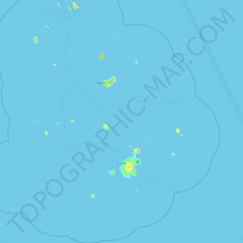
Name: Cuyo topographic map, elevation, terrain.
Location: Cuyo, Palawan, Mimaropa, 5318, Philippines (10.55793 120.47158 11.45374 121.20733)
Average elevation: 0 m
Minimum elevation: -1 m
Maximum elevation: 246 m
Make a donation
Other topographic maps
Click on a map to view its topography, its elevation and its terrain.
Make a donation
Make a donation
Make a donation
Make a donation
Make a donation
Make a donation
Make a donation
Make a donation
Make a donation
Make a donation
Make a donation
Make a donation
Make a donation
Make a donation
Make a donation
Make a donation
Make a donation
Make a donation
Make a donation
Make a donation
Likas Island
Philippines > Palawan > Kalayaan
West York Island, also known as Likas Island (Filipino: Pulo ng Likas, lit. 'Island of Naturality'; Mandarin Chinese: 西月島/西月岛; pinyin: Xīyuè Dǎo; Vietnamese: đảo Bến Lạc), and several other names. With an area of 18.6 hectares (46 acres), it is the third largest of the naturally…
Average elevation: 0 m
Make a donation
Make a donation
Make a donation
Make a donation
Make a donation