
Saint-Aubin-des-Hayes topographic map
Interactive map
Click on the map to display elevation.
About this map
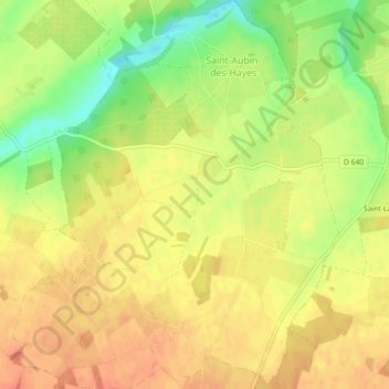
Name: Saint-Aubin-des-Hayes topographic map, elevation, terrain.
Average elevation: 169 m
Minimum elevation: 138 m
Maximum elevation: 187 m
Other topographic maps
Click on a map to view its topography, its elevation and its terrain.
Jonquerets-de-Livet
France > Normandy > Eure > Mesnil-en-Ouche
Jonquerets-de-Livet, Mesnil-en-Ouche, Bernay, Eure, Normandy, Metropolitan France, 27410, France
Average elevation: 173 m
Granchain
France > Normandy > Eure > Mesnil-en-Ouche
Granchain, Mesnil-en-Ouche, Bernay, Eure, Normandy, Metropolitan France, 27410, France
Average elevation: 165 m