
Lützen topographic map
Interactive map
Click on the map to display elevation.
About this map
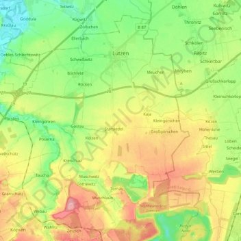
Name: Lützen topographic map, elevation, terrain.
Location: Lützen, Burgenlandkreis, Saxony-Anhalt, 06686, Germany (51.16610 11.99926 51.27874 12.20480)
Average elevation: 135 m
Minimum elevation: 89 m
Maximum elevation: 197 m
Other topographic maps
Click on a map to view its topography, its elevation and its terrain.
Aue
Germany > Saxony-Anhalt > Burgenlandkreis > Zeitz
Aue, Zeitz, Burgenlandkreis, Saxony-Anhalt, 06712, Germany
Average elevation: 174 m
Plößnitz
Germany > Saxony-Anhalt > Burgenlandkreis > Laucha an der Unstrut > Plößnitz
Plößnitz, Laucha an der Unstrut, Unstruttal, Burgenlandkreis, Saxony-Anhalt, 06636, Germany
Average elevation: 206 m
Tromsdorf
Germany > Saxony-Anhalt > Burgenlandkreis > Eckartsberga > Tromsdorf
Tromsdorf, Eckartsberga, An der Finne, Burgenlandkreis, Saxony-Anhalt, Germany
Average elevation: 195 m
Zeitz
Germany > Saxony-Anhalt > Burgenlandkreis
Zeitz, Burgenlandkreis, Saxony-Anhalt, Germany
Average elevation: 210 m