
Wusterwitz topographic map
Interactive map
Click on the map to display elevation.
About this map
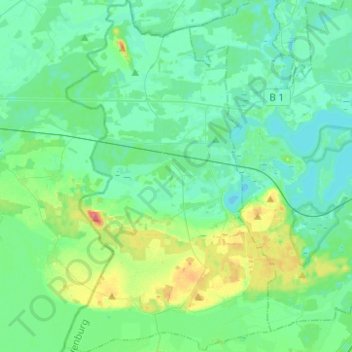
Name: Wusterwitz topographic map, elevation, terrain.
Average elevation: 38 m
Minimum elevation: 25 m
Maximum elevation: 84 m
Other topographic maps
Click on a map to view its topography, its elevation and its terrain.
Fohrde
Deutschland > Brandenburg > Potsdam-Mittelmark > Havelsee
Fohrde, Havelsee, Beetzsee, Potsdam-Mittelmark, Brandenburg, 14798, Deutschland
Average elevation: 33 m
Michendorf
Deutschland > Brandenburg > Potsdam-Mittelmark
Michendorf, Potsdam-Mittelmark, Brandenburg, 14552, Deutschland
Average elevation: 48 m