
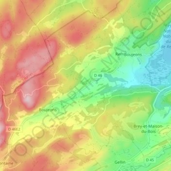
Remoray-Boujeons topographic map
Interactive map
Click on the map to display elevation.
Remoray-Boujeons
Remoray-Boujeons liegt auf 916 m über dem Meeresspiegel, etwa 17 Kilometer südwestlich der Stadt Pontarlier (Luftlinie). Die Doppelgemeinde erstreckt sich im Jura, in einer Längsmulde westlich des Lac de Remoray und des Doubstals auf der Südabdachung der Höhe der Grand-Côte.
About this map
Name: Remoray-Boujeons topographic map, elevation, terrain.
Average elevation: 959 m
Minimum elevation: 847 m
Maximum elevation: 1,118 m
Other topographic maps
Click on a map to view its topography, its elevation and its terrain.
Forêt Communale de Pontarlier - Série 4
Frankreich > Burgund und Freigrafschaft > Doubs > Pontarlier > Les Boulots
Average elevation: 1,021 m