
Ségur topographic map
Interactive map
Click on the map to display elevation.
About this map
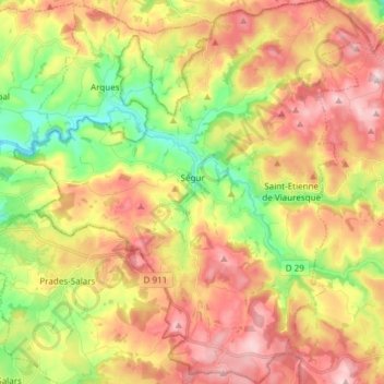
Name: Ségur topographic map, elevation, terrain.
Average elevation: 867 m
Minimum elevation: 716 m
Maximum elevation: 1,016 m
Other topographic maps
Click on a map to view its topography, its elevation and its terrain.
Palmas
France > Occitania > Aveyron > Palmas d'Aveyron
Palmas, Palmas d'Aveyron, Rodez, Aveyron, Occitania, Metropolitan France, 12310, France
Average elevation: 613 m