
Make a donation
Zuffenhausen topographic map
Click on the map to display elevation.
Make a donation
Zuffenhausen
Zuffenhausen's terrain, a river valley carved into existence by the Feuerbach river, has two distinct elevations: Zuffenhausen with an average of 255 m (837 ft) and Zazenhausen at 252 m (827 ft). To the north and northwest are the vast stretches of the Langes Feld rolling hills on a height of over 300 m (980 ft) that peak at 327 m (1,073 ft) near Neuwirtshaus, an area that constitutes the eastern Strohgäu, a rich farmland largely free of trees. To the south are the Stuttgart Mountains and the Neckar valley to the east, followed by the Schurwald mountains. Irregular ascents are characteristic for the Zuffenhausen region, of which Burgholzhof is the highest at 359 m (1,178 ft) above sea level.
Make a donation
About this map
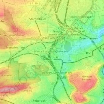
Name: Zuffenhausen topographic map, elevation, terrain.
Location: Zuffenhausen, Stuttgart, Baden-Württemberg, Germany (48.81754 9.13709 48.85155 9.20962)
Average elevation: 301 m
Minimum elevation: 237 m
Maximum elevation: 379 m
Make a donation