
Province of Carhuaz topographic map
Interactive map
Click on the map to display elevation.
About this map
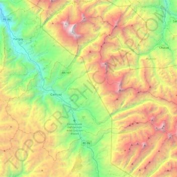
Name: Province of Carhuaz topographic map, elevation, terrain.
Location: Province of Carhuaz, Ancash, Peru (-9.45280 -77.77670 -9.08191 -77.31813)
Average elevation: 4,038 m
Minimum elevation: 2,248 m
Maximum elevation: 6,726 m
Other topographic maps
Click on a map to view its topography, its elevation and its terrain.
Laguna Palococha
Laguna Palococha, AN-110, Ticapampa, Province of Recuay, Ancash, Peru
Average elevation: 3,750 m
Laguna Palococha
Laguna Palococha, AN-110, Ticapampa, Province of Recuay, Ancash, Peru
Average elevation: 3,765 m
Province of Huaylas
Peru > Ancash > Santa Cruz
Province of Huaylas, Santa Cruz, Huaylas, Ancash, Peru
Average elevation: 2,353 m
Province of Recuay
Province of Recuay, Cátac, Recuay, Ancash, Peru
Average elevation: 4,232 m
Laguna Palococha
Laguna Palococha, AN-110, Ticapampa, Recuay, Ancash, Peru
Average elevation: 3,765 m