
Thank you for supporting this site ❤️
Make a donation
Make a donation
Thanet topographic map
Click on the map to display elevation.
Thank you for supporting this site ❤️
Make a donation
Make a donation
About this map
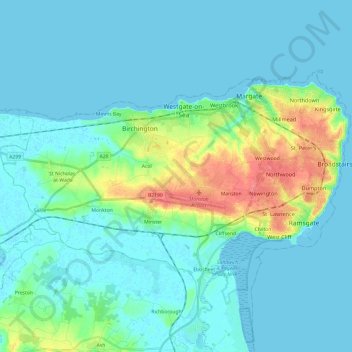
Name: Thanet topographic map, elevation, terrain.
Location: Thanet, Kent, England, United Kingdom (51.30797 1.21075 51.39881 1.45177)
Average elevation: 10 m
Minimum elevation: -1 m
Maximum elevation: 57 m
Thank you for supporting this site ❤️
Make a donation
Make a donation
Other topographic maps
Click on a map to view its topography, its elevation and its terrain.