
Wuzhong City topographic map
Interactive map
Click on the map to display elevation.
About this map
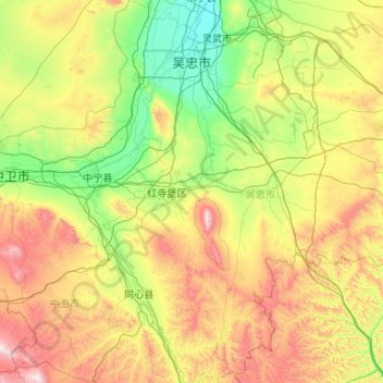
Name: Wuzhong City topographic map, elevation, terrain.
Location: Wuzhong City, Ningxia, China (36.57858 105.55570 38.26078 107.65254)
Average elevation: 1,493 m
Minimum elevation: 1,109 m
Maximum elevation: 2,618 m
Topography: Wuzhong city is long from east to west and narrow from north to south. The topography is high in the south and low in the north, with Yinchuan plain in the north and Qingtongxia plain and hilly land in the south. Sichuan district dry average elevation of 1100 meters, the mountain elevation of 1300–1900 meters. The city's landform is made up of loess plateau, ordos platform, Yellow River alluvial plain and l mountain.