
Jeli topographic map
Click on the map to display elevation.
About this map
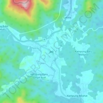
Name: Jeli topographic map, elevation, terrain.
Location: Jeli, Kelantan, Malaysia (5.65552 101.80494 5.73552 101.88494)
Average elevation: 153 m
Minimum elevation: 47 m
Maximum elevation: 866 m
Other topographic maps
Click on a map to view its topography, its elevation and its terrain.
Kuala Krai
Kuala Krai (alternative spelling: Kuala Kerai, Jawi: كوالا كراي) is a town located in the coterminous Kuala Krai District in southern-central Kelantan, Malaysia. During British protection it was known as Kuala Lebir. It is 67 km from state capital Kota Bharu and 273 km from national capital Kuala…
Average elevation: 249 m