
Thank you for supporting this site ❤️
Make a donation
Make a donation
Haveli topographic map
Click on the map to display elevation.
Thank you for supporting this site ❤️
Make a donation
Make a donation
About this map
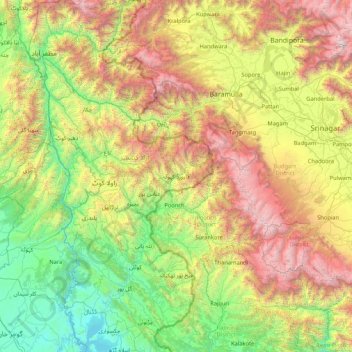
Name: Haveli topographic map, elevation, terrain.
Location: Haveli, Poonch Division, Azad Kashmir, Pakistan (33.18000 73.40523 34.58000 74.80523)
Average elevation: 1,784 m
Minimum elevation: 333 m
Maximum elevation: 5,101 m
Thank you for supporting this site ❤️
Make a donation
Make a donation
Other topographic maps
Click on a map to view its topography, its elevation and its terrain.
Barnala Tehsil
Pakistan > Azad Kashmir > Bhimber District
Topographically, Barnala is divided into four regions.
Average elevation: 412 m