
Thank you for supporting this site ❤️
Make a donation
Make a donation
Baxter Village topographic map
Click on the map to display elevation.
Thank you for supporting this site ❤️
Make a donation
Make a donation
About this map
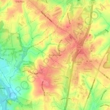
Name: Baxter Village topographic map, elevation, terrain.
Average elevation: 191 m
Minimum elevation: 149 m
Maximum elevation: 218 m
Thank you for supporting this site ❤️
Make a donation
Make a donation
Other topographic maps
Click on a map to view its topography, its elevation and its terrain.
Lesslie
United States > South Carolina > York County
Lesslie has a total area of 6.0 square miles (16 km2), and an elevation of 701 feet (214 m).
Average elevation: 193 m
Kings Mountain National Military Park
United States > South Carolina > York County > Blacksburg
Average elevation: 241 m
Thank you for supporting this site ❤️
Make a donation
Make a donation