
Thank you for supporting this site ❤️
Make a donation
Make a donation
Langenhaeuser topographic map
Click on the map to display elevation.
Thank you for supporting this site ❤️
Make a donation
Make a donation
About this map
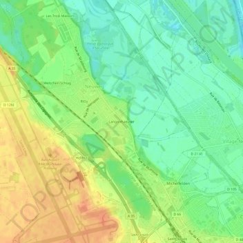
Name: Langenhaeuser topographic map, elevation, terrain.
Average elevation: 252 m
Minimum elevation: 233 m
Maximum elevation: 273 m
Thank you for supporting this site ❤️
Make a donation
Make a donation
Other topographic maps
Click on a map to view its topography, its elevation and its terrain.
Square Saint-Charles du Bourgfelden
France > Grand Est > Haut-Rhin > Saint-Louis
Average elevation: 269 m