
Thank you for supporting this site ❤️
Make a donation
Make a donation
Tignes topographic map
Click on the map to display elevation.
Thank you for supporting this site ❤️
Make a donation
Make a donation
Tignes
The terrain of valley lends itself to more challenging skiing, with advanced skiers often opting for the resort as their preferred ski area. The town has however strived to improve its appeal to beginner and intermediate skiers with the introduction of easier runs lower down in the valley towards Tignes-Les-Brévières and upgrading existing chairlifts and installing new ones with smaller elevation gains.
Thank you for supporting this site ❤️
Make a donation
Make a donation
About this map
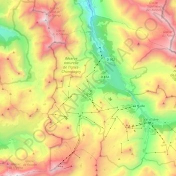
Name: Tignes topographic map, elevation, terrain.
Average elevation: 2,520 m
Minimum elevation: 1,387 m
Maximum elevation: 3,811 m
Thank you for supporting this site ❤️
Make a donation
Make a donation
Other topographic maps
Click on a map to view its topography, its elevation and its terrain.