
Make a donation
Price Township topographic map
Click on the map to display elevation.
Make a donation
About this map
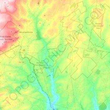
Name: Price Township topographic map, elevation, terrain.
Location: Price Township, Monroe County, Pennsylvania, United States (41.06303 -75.24949 41.21878 -75.13836)
Average elevation: 350 m
Minimum elevation: 171 m
Maximum elevation: 623 m
Make a donation
Other topographic maps
Click on a map to view its topography, its elevation and its terrain.
Blue Mountain
United States > Pennsylvania > Monroe County > Eldred Township
The ridge of Blue Mountain runs for 150 miles (240 km) through Pennsylvania, reaching an elevation of 2,270 feet (690 m) above sea level just north of the Pennsylvania Turnpike, near the borough of Newburg. Most of the ridgecrest, however, only reaches between 1,400 and 1,700 feet (430 and 520 m) in elevation.…
Average elevation: 242 m
Mount Nebo Park
United States > Pennsylvania > Monroe County > East Stroudsburg > Twin Falls
Average elevation: 185 m
Skytop
United States > Pennsylvania > Monroe County > Barrett Township
Skytop is an unincorporated community in Barrett Township, Monroe County, Pennsylvania, United States. Located north of Mountainhome, it is accessible by local roads off Route 390. Its elevation is 1,562 feet (476 m), and it is located at 41°13′40″N 75°14′18″W / 41.22778°N 75.23833°W /…
Average elevation: 469 m
Make a donation
Pocono Lake
United States > Pennsylvania > Monroe County > Tobyhanna Township
Average elevation: 543 m
Kunkletown
United States > Pennsylvania > Monroe County > Eldred Township
Kunkletown is an unincorporated community in Eldred Township, Monroe County, Pennsylvania, United States. It is located at an elevation of 531 feet. It is at ZIP Code 18058.
Average elevation: 224 m
Make a donation
Long Pond
United States > Pennsylvania > Monroe County > Tunkhannock Township
Long Pond is named after the unique wetland topography formed by the Tunkhannock Creek. Within the Long Pond community, public access lands are owned and protected by The Bethlehem Authority, Nature Conservancy, Wildlands Conservancy County of Monroe Open Space Program, , PA Game Commission and PA Department…
Average elevation: 571 m
Make a donation
Marshalls Creek
United States > Pennsylvania > Monroe County > Smithfield Township
Average elevation: 186 m
Make a donation
Pocono Summit
United States > Pennsylvania > Monroe County > Tobyhanna Township
Average elevation: 547 m
Shawnee on Delaware
United States > Pennsylvania > Monroe County > Smithfield Township
Average elevation: 188 m
Make a donation
Long Pond
United States > Pennsylvania > Monroe County > Tunkhannock Township
Long Pond is named after the wetland topography formed by Tunkhannock Creek. Within the Long Pond community are public access lands, containing many species of plants and animals. Long Pond has been called "the most unique inland freshwater wetland in the state".
Average elevation: 571 m
Camelback Mountain
United States > Pennsylvania > Monroe County > Jackson Township
Average elevation: 458 m
Make a donation
Pocono Lake
United States > Pennsylvania > Monroe County > Tobyhanna Township
Average elevation: 543 m
Long Pond
United States > Pennsylvania > Monroe County > Tunkhannock Township
Long Pond is named after the wetland topography formed by Tunkhannock Creek. Within the Long Pond community are public access lands, containing many species of plants and animals. Long Pond has been called "the most unique inland freshwater wetland in the state".
Average elevation: 571 m
Make a donation