
Make a donation
Edison topographic map
Click on the map to display elevation.
Make a donation
Edison
While the Township's topography is mostly flat, there are some more hilly areas in the township. The highest point is on Grandview Avenue, which reaches a maximum elevation of about 220 feet, which is the highest point in the Township. The lowest elevation in the township is on sea level on the Raritan River.
Make a donation
About this map
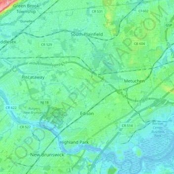
Name: Edison topographic map, elevation, terrain.
Location: Edison, Middlesex County, New Jersey, United States (40.47136 -74.44032 40.60550 -74.31605)
Average elevation: 25 m
Minimum elevation: -2 m
Maximum elevation: 155 m
Make a donation
Other topographic maps
Click on a map to view its topography, its elevation and its terrain.
North Stelton
United States > New Jersey > Middlesex County > Piscataway Township
Average elevation: 29 m
Frost Woods Park
United States > New Jersey > Middlesex County > East Brunswick Township
Average elevation: 29 m
Make a donation
Make a donation
Middlesex Downs
United States > New Jersey > Middlesex County > Monroe Township
Average elevation: 33 m
Elmer B Boyd Park
United States > New Jersey > Middlesex County > New Brunswick > Feaster Park
Average elevation: 22 m
Make a donation
Possumtown
United States > New Jersey > Middlesex County > Piscataway Township
Average elevation: 19 m
Lawrence Brook Manor
United States > New Jersey > Middlesex County > East Brunswick Township
Average elevation: 19 m
Randolphville
United States > New Jersey > Middlesex County > Piscataway Township
Average elevation: 26 m
Make a donation
Paulas Corners
United States > New Jersey > Middlesex County > East Brunswick Township
Average elevation: 29 m
Randolphville
United States > New Jersey > Middlesex County > Piscataway Township
Average elevation: 26 m
Woodbridge
United States > New Jersey > Middlesex County > Woodbridge Township
Average elevation: 16 m
Make a donation
North Stelton
United States > New Jersey > Middlesex County > Piscataway Township
Average elevation: 29 m
Make a donation
Lynn Woodoaks
United States > New Jersey > Middlesex County > Woodbridge Township > Colonia
Average elevation: 31 m
Make a donation
Fieldville
United States > New Jersey > Middlesex County > Piscataway Township
Average elevation: 17 m
Sand Hills
United States > New Jersey > Middlesex County > Woodbridge Township > Fords
Average elevation: 24 m
Prospect Plains
United States > New Jersey > Middlesex County > Monroe Township
Average elevation: 39 m
Make a donation
Berdines Corners
United States > New Jersey > Middlesex County > North Brunswick
Average elevation: 29 m
Make a donation
Make a donation
South River
United States > New Jersey > Middlesex County > South River > South River
Average elevation: 19 m
Make a donation
Highland Park
United States > New Jersey > Middlesex County > Highland Park > Highland Park
Average elevation: 24 m
New Market
United States > New Jersey > Middlesex County > Piscataway Township
Average elevation: 23 m
Fairview Knolls
United States > New Jersey > Middlesex County > East Brunswick Township
Average elevation: 31 m
Make a donation