
Thank you for supporting this site ❤️
Make a donation
Make a donation
Penha de França topographic map
Click on the map to display elevation.
Thank you for supporting this site ❤️
Make a donation
Make a donation
About this map
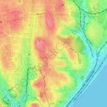
Name: Penha de França topographic map, elevation, terrain.
Location: Penha de França, Lisbon, Portugal (38.72140 -9.13311 38.73300 -9.12166)
Average elevation: 56 m
Minimum elevation: -2 m
Maximum elevation: 110 m
Thank you for supporting this site ❤️
Make a donation
Make a donation