
Saint-Maurice topographic map
Interactive map
Click on the map to display elevation.
About this map
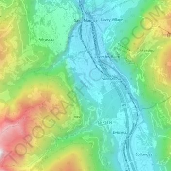
Name: Saint-Maurice topographic map, elevation, terrain.
Location: Saint-Maurice, Sankt Moritz, Wallis, 1890, Schweiz (46.16695 6.94565 46.22553 7.03468)
Average elevation: 982 m
Minimum elevation: 397 m
Maximum elevation: 2,447 m
Other topographic maps
Click on a map to view its topography, its elevation and its terrain.
Mex (VS)
Schweiz > Wallis > Sankt Moritz > Mex (VS)
Mex (VS), Saint-Maurice, Sankt Moritz, Wallis, 1890, Schweiz
Average elevation: 957 m