
ทับใต้ topographic map
Interactive map
Click on the map to display elevation.
About this map
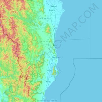
Name: ทับใต้ topographic map, elevation, terrain.
Location: ทับใต้, Prachuap Khiri Khan, Thaïlande (11.79001 99.20406 13.19001 100.60406)
Average elevation: 151 m
Minimum elevation: -1 m
Maximum elevation: 1,458 m
Other topographic maps
Click on a map to view its topography, its elevation and its terrain.
ถ้ำพระยานคร
Thaïlande > Prachuap Khiri Khan > บ้านหุบตาโคตร
ถ้ำพระยานคร, สามร้อยยอด 33, บ้านหุบตาโคตร, Prachuap Khiri Khan, Thaïlande
Average elevation: 25 m
หินเหล็กไฟ
Thaïlande > Prachuap Khiri Khan > หินเหล็กไฟ
หินเหล็กไฟ, Prachuap Khiri Khan, Thaïlande
Average elevation: 168 m