
Innerlangesthei topographic map
Interactive map
Click on the map to display elevation.
About this map
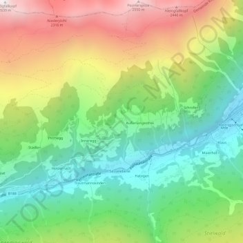
Name: Innerlangesthei topographic map, elevation, terrain.
Average elevation: 1,655 m
Minimum elevation: 1,031 m
Maximum elevation: 2,616 m
Other topographic maps
Click on a map to view its topography, its elevation and its terrain.
Ulmich
Oostenrijk > Tirol > Bezirk Landeck > Gemeinde Kappl
Ulmich, Gemeinde Kappl, Bezirk Landeck, Tirol, 6555, Oostenrijk
Average elevation: 1,760 m