
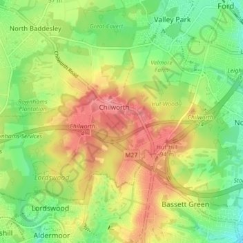
Chilworth topographic map
Interactive map
Click on the map to display elevation.
About this map
Name: Chilworth topographic map, elevation, terrain.
Average elevation: 49 m
Minimum elevation: 8 m
Maximum elevation: 96 m
Other topographic maps
Click on a map to view its topography, its elevation and its terrain.
Barton Stacey
United Kingdom > England > Test Valley
Barton Stacey, Test Valley, Hampshire, South East, England, United Kingdom
Average elevation: 75 m
Kimpton
United Kingdom > England > Test Valley
Kimpton, Test Valley, Hampshire, South East, England, United Kingdom
Average elevation: 111 m
Test Valley
United Kingdom > England > Test Valley
Test Valley, Hampshire, South East, England, United Kingdom
Average elevation: 97 m
Romsey
United Kingdom > England > Test Valley
Romsey, Test Valley, Hampshire, South East, England, United Kingdom
Average elevation: 25 m