
Dangcagan topographic map
Click on the map to display elevation.
Dangcagan
It has a fertile soil ranging from clay to sandy loam. Its topography is 70% flat and 30% rolling, which is suitable for agricultural crops such as corn, rice and other commercial crops like coconut, coffee, cacao, rubber, banana and sugar cane.
About this map
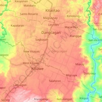
Name: Dangcagan topographic map, elevation, terrain.
Location: Dangcagan, Bukidnon, Northern Mindanao, 8719, Philippines (7.53847 124.94077 7.63987 125.06646)
Average elevation: 322 m
Minimum elevation: 89 m
Maximum elevation: 490 m
Other topographic maps
Click on a map to view its topography, its elevation and its terrain.