
Thank you for supporting this site ❤️
Make a donation
Make a donation
Sorède topographic map
Click on the map to display elevation.
Thank you for supporting this site ❤️
Make a donation
Make a donation
About this map
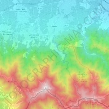
Name: Sorède topographic map, elevation, terrain.
Average elevation: 428 m
Minimum elevation: 15 m
Maximum elevation: 1,246 m
Thank you for supporting this site ❤️
Make a donation
Make a donation
Other topographic maps
Click on a map to view its topography, its elevation and its terrain.
Villeneuve-des-Escaldes
France > Occitania > Pyrénées-Orientales > Angoustrine-Villeneuve-des-Escaldes
Average elevation: 1,372 m