
Napf topographic map
Interactive map
Click on the map to display elevation.
About this map
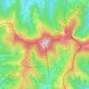
Name: Napf topographic map, elevation, terrain.
Average elevation: 1,156 m
Minimum elevation: 958 m
Maximum elevation: 1,401 m
Other topographic maps
Click on a map to view its topography, its elevation and its terrain.
Ober Schwarzentrub
Schweiz > Bern > Verwaltungskreis Emmental > Trub
Ober Schwarzentrub, Trub, Verwaltungskreis Emmental, Verwaltungsregion Emmental-Oberaargau, Bern, 3557, Schweiz
Average elevation: 975 m
Trub
Schweiz > Bern > Verwaltungskreis Emmental > Trub
Trub, Verwaltungskreis Emmental, Verwaltungsregion Emmental-Oberaargau, Bern, Schweiz
Average elevation: 990 m