
Make a donation
Waimakariri District topographic map
Click on the map to display elevation.
Make a donation
About this map
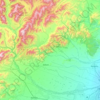
Name: Waimakariri District topographic map, elevation, terrain.
Location: Waimakariri District, Canterbury, New Zealand (-43.46078 171.92840 -42.95422 172.73605)
Average elevation: 476 m
Minimum elevation: 1 m
Maximum elevation: 1,930 m
Make a donation
Other topographic maps
Click on a map to view its topography, its elevation and its terrain.
Mount Cook
New Zealand > Canterbury > Mackenzie District
Aoraki / Mount Cook is the highest mountain in New Zealand. Its height, as of 2014, is listed as 3,724 metres (12,218 feet). It sits in the Southern Alps, the mountain range that runs the length of the South Island. A popular tourist destination, it is also a favourite challenge for mountain climbers. Aoraki /…
Average elevation: 2,920 m
Make a donation
Ohinepaka Bay
New Zealand > Canterbury > Christchurch City > Banks Peninsula Community > Wainui
Average elevation: 94 m
Make a donation
Zig Zag
New Zealand > Canterbury > Christchurch City > Banks Peninsula Community
Average elevation: 136 m
Make a donation
Hanmer Springs
New Zealand > Canterbury > Hurunui District
The Jacks Pass – Clarence River – Jollies Pass Loop is a 25 kilometer loop which is not technically challenging however it takes between two to four hours to complete. It can be ridden in either direction: West over Jacks Pass (869m) or East over Jollies Pass (850m). As the entire ride is at high elevation…
Average elevation: 397 m
Make a donation
Lyttelton
New Zealand > Canterbury > Christchurch City > Banks Peninsula Community
Average elevation: 99 m
Make a donation