
Make a donation
Banan District topographic map
Click on the map to display elevation.
Make a donation
Banan District
Banan, situated in the southern part of the Sichuan Basin, has a diversity of terrains including mountains, hills, wetlands and flood beds. The lowest point of the district is on its northern border with Nan'an District, at an altitude of 154 meters. The highest point is the top of Fangdou Mountain in the southeast of the district, at an altitude of 1132.6 meters.
Make a donation
About this map
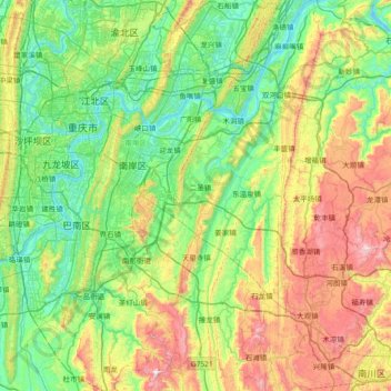
Name: Banan District topographic map, elevation, terrain.
Location: Banan District, Chongqing, China (29.12945 106.43131 29.77339 106.99832)
Average elevation: 445 m
Minimum elevation: 140 m
Maximum elevation: 1,186 m
Make a donation
Other topographic maps
Click on a map to view its topography, its elevation and its terrain.
Chongqing
The central urban area of Chongqing, or Chongqing proper, is a city of unique features. Built on mountains and partially surrounded by the Yangtze and Jialing rivers, it is known as a "mountain city" and a "city on rivers". The night scene of the city is very illuminated, with millions of lights and their…
Average elevation: 318 m
Make a donation
Make a donation
Make a donation
Make a donation
Make a donation
Make a donation
Make a donation