
Thank you for supporting this site ❤️
Make a donation
Make a donation
Cajamarca topographic map
Click on the map to display elevation.
Thank you for supporting this site ❤️
Make a donation
Make a donation
Cajamarca
Cajamarca has a subtropical highland climate (Cwb, in the Köppen climate classification) which is characteristic of high elevations at tropical latitudes. This city presents a semi-dry, temperate, semi-cold climate with presence of rainfall mostly on spring and summer (from October to March) with little or no rainfall the rest of the year.
Thank you for supporting this site ❤️
Make a donation
Make a donation
About this map
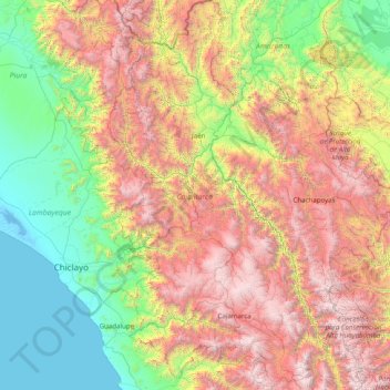
Name: Cajamarca topographic map, elevation, terrain.
Location: Cajamarca, Peru (-7.76346 -79.45845 -4.62395 -77.74130)
Average elevation: 1,456 m
Minimum elevation: -4 m
Maximum elevation: 4,585 m
Thank you for supporting this site ❤️
Make a donation
Make a donation