
Zona Reservada Cordillera Huayhuash topographic map
Interactive map
Click on the map to display elevation.
About this map
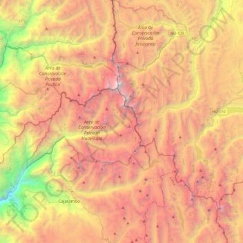
Name: Zona Reservada Cordillera Huayhuash topographic map, elevation, terrain.
Average elevation: 4,319 m
Minimum elevation: 1,836 m
Maximum elevation: 6,483 m
Other topographic maps
Click on a map to view its topography, its elevation and its terrain.
Plaza de Armas
Perú > Lima > Cajatambo > Utcas
Plaza de Armas, Utcas, Cajatambo, Provincia de Cajatambo, Lima, Perú
Average elevation: 3,322 m
Provincia de Cajatambo
Provincia de Cajatambo, Cajatambo, Lima, Perú
Average elevation: 4,519 m