
Thank you for supporting this site ❤️
Make a donation
Make a donation
Les Terriers topographic map
Click on the map to display elevation.
Thank you for supporting this site ❤️
Make a donation
Make a donation
About this map
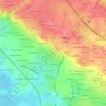
Name: Les Terriers topographic map, elevation, terrain.
Average elevation: 41 m
Minimum elevation: -2 m
Maximum elevation: 78 m
Thank you for supporting this site ❤️
Make a donation
Make a donation
Other topographic maps
Click on a map to view its topography, its elevation and its terrain.
Lac de Beaulieu
France > Pays de la Loire > Loire-Atlantique > Couëron > La Gergauderie
Average elevation: 25 m