
Thank you for supporting this site ❤️
Make a donation
Make a donation
Highlands Ranch topographic map
Click on the map to display elevation.
Thank you for supporting this site ❤️
Make a donation
Make a donation
About this map
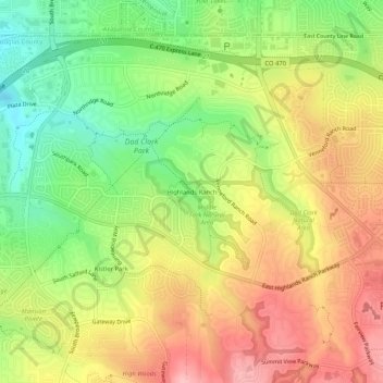
Name: Highlands Ranch topographic map, elevation, terrain.
Average elevation: 1,758 m
Minimum elevation: 1,683 m
Maximum elevation: 1,831 m
Thank you for supporting this site ❤️
Make a donation
Make a donation
Other topographic maps
Click on a map to view its topography, its elevation and its terrain.
Parker
United States > Colorado > Douglas County
Parker is located in northeastern Douglas County. Its northernmost border follows the Arapahoe County line, and the city of Aurora touches the town's northeast border. The center of Parker is 23 miles (37 km) southeast of downtown Denver. Castle Rock, the Douglas County seat, is 15 miles (24 km) to the…
Average elevation: 1,845 m