
Thank you for supporting this site ❤️
Make a donation
Make a donation
Mont Faron topographic map
Click on the map to display elevation.
Thank you for supporting this site ❤️
Make a donation
Make a donation
About this map
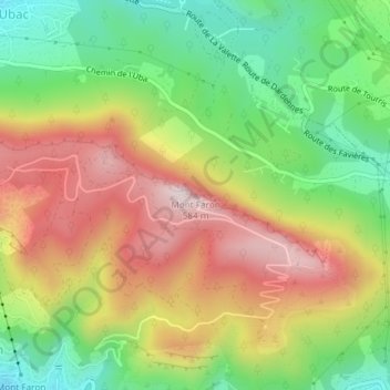
Name: Mont Faron topographic map, elevation, terrain.
Average elevation: 313 m
Minimum elevation: 81 m
Maximum elevation: 574 m
Thank you for supporting this site ❤️
Make a donation
Make a donation
Other topographic maps
Click on a map to view its topography, its elevation and its terrain.
Fort du Grand-Saint-Antoine
France > Provence-Alpes-Côte d'Azur > Var > Toulon
Average elevation: 121 m