
Lewis and Clark County topographic map
Interactive map
Click on the map to display elevation.
About this map
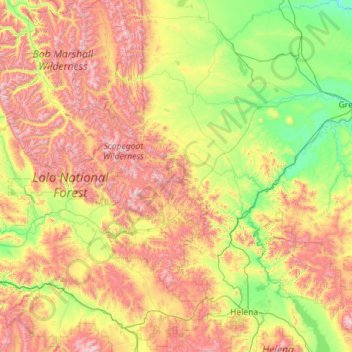
Name: Lewis and Clark County topographic map, elevation, terrain.
Location: Lewis and Clark County, Montana, United States of America (46.41491 -113.16597 47.95398 -111.49465)
Average elevation: 1,554 m
Minimum elevation: 970 m
Maximum elevation: 2,833 m
Other topographic maps
Click on a map to view its topography, its elevation and its terrain.
Bozeman
United States of America > Montana > Bozeman
Bozeman, Gallatin County, Montana, United States of America
Average elevation: 1,495 m
West Glacier
United States of America > Montana > West Glacier
West Glacier, Flathead County, Montana, 59936, United States of America
Average elevation: 1,201 m
Granite County
United States of America > Montana
Granite County, Montana, United States of America
Average elevation: 1,800 m