
Thank you for supporting this site ❤️
Make a donation
Make a donation
21st district topographic map
Click on the map to display elevation.
Thank you for supporting this site ❤️
Make a donation
Make a donation
About this map
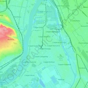
Name: 21st district topographic map, elevation, terrain.
Location: 21st district, Budapest, Central Hungary, Hungary (47.38493 19.01895 47.46193 19.10914)
Average elevation: 110 m
Minimum elevation: 89 m
Maximum elevation: 194 m
Thank you for supporting this site ❤️
Make a donation
Make a donation