
Make a donation
Danta di Cadore topographic map
Click on the map to display elevation.
Make a donation
About this map
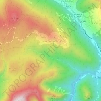
Name: Danta di Cadore topographic map, elevation, terrain.
Location: Danta di Cadore, Belluno, Veneto, 32040, Italy (46.54258 12.48639 46.58237 12.52919)
Average elevation: 1,230 m
Minimum elevation: 867 m
Maximum elevation: 1,657 m
Make a donation
Other topographic maps
Click on a map to view its topography, its elevation and its terrain.
Make a donation
Make a donation
Make a donation
Make a donation
Make a donation
Monte Schiara
Italy > Veneto > Belluno > Sedico
The Schiara (Italian: Monte Schiara) is a mountain in the southern Dolomites of Veneto in northern Italy. It is located just north of the town of Belluno, approximately 50 miles north of Venice. Monte Schiara has an elevation of 2,565 metres.
Average elevation: 1,852 m
Make a donation
Make a donation
Make a donation
Cortina d'Ampezzo
Italy > Veneto > Belluno > Cortina d'Ampezzo > Cortina d'Ampezzo
Among the surrounding mountains are Tofane to the west, Pomagagnon to the north, Cristallo to the northeast, Faloria and Sorapiss to the east, and Becco di Mezzodì, Croda da Lago and Cinque Torri to the south. Monte Antelao (Nantelou in Ladin) is at 3264 m the highest mountain in the Ampezzo Dolomites and the…
Average elevation: 1,649 m
Tre Cime di Lavaredo - Drei Zinnen
Italy > Veneto > Belluno > Auronzo di Cadore
Until 1919 the peaks formed part of the border between Italy and Austria-Hungary. Now they lie on the border between the Italian provinces of South Tyrol and Belluno and still are a part of the linguistic boundary between German-speaking and Italian-speaking majorities. The Cima Grande has an elevation of…
Average elevation: 2,242 m
Make a donation
Sas de Stria
Italy > Veneto > Belluno > Cortina d'Ampezzo
Sass de Stria is a mountain of the Veneto, Italy. It has an elevation of 2,477 meters. During the First World War, the mountain and surrounding area was the scene of fighting between Italy and Austria-Hungary.
Average elevation: 2,138 m
Make a donation
Pieve di Cadore
Italy > Veneto > Belluno > Pieve di Cadore > Pieve di Cadore
Average elevation: 1,116 m