
Thank you for supporting this site ❤️
Make a donation
Make a donation
Beauregard topographic map
Click on the map to display elevation.
Thank you for supporting this site ❤️
Make a donation
Make a donation
About this map
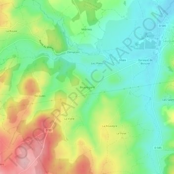
Name: Beauregard topographic map, elevation, terrain.
Average elevation: 990 m
Minimum elevation: 921 m
Maximum elevation: 1,102 m
Thank you for supporting this site ❤️
Make a donation
Make a donation
Other topographic maps
Click on a map to view its topography, its elevation and its terrain.
Donjon dit Tour des Anglais
France > Auvergne-Rhône-Alpes > Haute-Loire > Saugues
Average elevation: 976 m