
Sacra topographic map
Interactive map
Click on the map to display elevation.
About this map
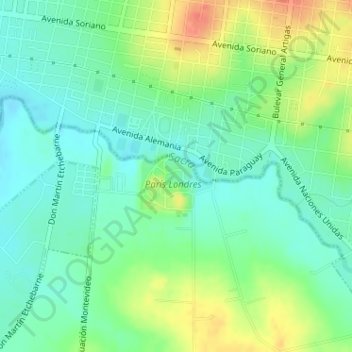
Name: Sacra topographic map, elevation, terrain.
Location: Sacra, Paysandú, 60000, Uruguay (-32.34293 -58.09807 -32.33070 -58.06706)
Average elevation: 23 m
Minimum elevation: 4 m
Maximum elevation: 56 m
Other topographic maps
Click on a map to view its topography, its elevation and its terrain.