
Bouhamdoune topographic map
Interactive map
Click on the map to display elevation.
About this map
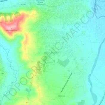
Name: Bouhamdoune topographic map, elevation, terrain.
Location: Bouhamdoune, Emir Abdelkader, Daïra Taher, Jijel, 18038, Algérie (36.76450 5.82292 36.80450 5.86292)
Average elevation: 37 m
Minimum elevation: -1 m
Maximum elevation: 143 m
Other topographic maps
Click on a map to view its topography, its elevation and its terrain.
Tassoust
Algérie > Jijel > Daïra Taher > Emir Abdelkader > Tassoust
Tassoust, Emir Abdelkader, Daïra Taher, Jijel, Algérie
Average elevation: 15 m