
Schreiersgrün topographic map
Interactive map
Click on the map to display elevation.
About this map
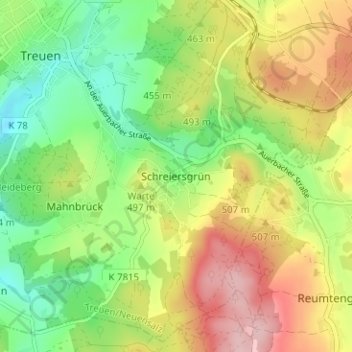
Name: Schreiersgrün topographic map, elevation, terrain.
Average elevation: 478 m
Minimum elevation: 396 m
Maximum elevation: 584 m
Other topographic maps
Click on a map to view its topography, its elevation and its terrain.
Pfaffengrün
Deutschland > Sachsen > Vogtlandkreis > Treuen
Pfaffengrün, Treuen, Treuen/Neuensalz, Vogtlandkreis, Sachsen, 08233, Deutschland
Average elevation: 450 m
Eich
Deutschland > Sachsen > Vogtlandkreis > Treuen
Eich, Treuen, Treuen/Neuensalz, Vogtlandkreis, Sachsen, 08233, Deutschland
Average elevation: 474 m