
Linwood-Central-Heathcote Community topographic map
Interactive map
Click on the map to display elevation.
About this map
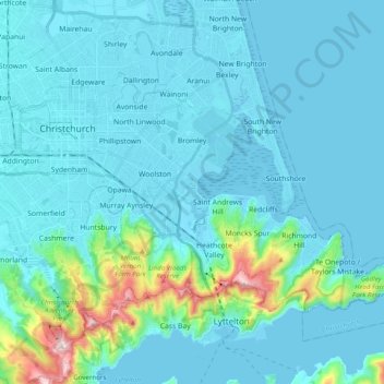
Name: Linwood-Central-Heathcote Community topographic map, elevation, terrain.
Average elevation: 55 m
Minimum elevation: -3 m
Maximum elevation: 500 m
Other topographic maps
Click on a map to view its topography, its elevation and its terrain.
Halswell-Hornby-Riccarton Community
New Zealand > Canterbury > Christchurch City
Halswell-Hornby-Riccarton Community, Christchurch City, Canterbury, New Zealand
Average elevation: 49 m
Christchurch
New Zealand > Canterbury > Christchurch City > Christchurch
Christchurch, Christchurch City, Canterbury, New Zealand
Average elevation: 41 m