
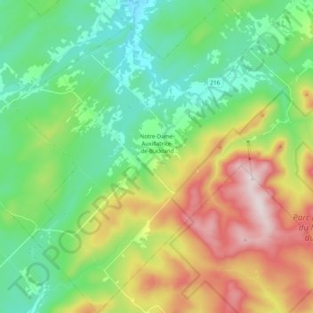
Notre-Dame-Auxiliatrice-de-Buckland topographic map
Interactive map
Click on the map to display elevation.
About this map
Name: Notre-Dame-Auxiliatrice-de-Buckland topographic map, elevation, terrain.
Average elevation: 514 m
Minimum elevation: 313 m
Maximum elevation: 910 m
Other topographic maps
Click on a map to view its topography, its elevation and its terrain.
Saint-Philémon
Canada > Québec > Bellechasse
Saint-Philémon, Bellechasse, Chaudière-Appalaches, Québec, Canada
Average elevation: 522 m
Saint-Michel-de-Bellechasse
Canada > Québec > Bellechasse
Saint-Michel-de-Bellechasse, Bellechasse, Chaudière-Appalaches, Québec, Canada
Average elevation: 50 m