
Arnoga topographic map
Interactive map
Click on the map to display elevation.
About this map
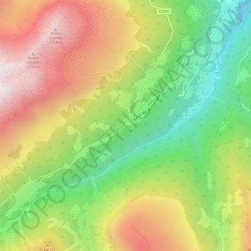
Name: Arnoga topographic map, elevation, terrain.
Average elevation: 2,068 m
Minimum elevation: 1,415 m
Maximum elevation: 2,796 m
Other topographic maps
Click on a map to view its topography, its elevation and its terrain.
Pradelle
Italië > Lombardije > Sondrio > Valdidentro > San Carlo > Semogo
Pradelle, Semogo, San Carlo, Valdidentro, Comunità montana Alta Valtellina, Sondrio, Lombardije, 23038, Italië
Average elevation: 1,744 m