
Thank you for supporting this site ❤️
Make a donation
Make a donation
Flirsch topographic map
Click on the map to display elevation.
Thank you for supporting this site ❤️
Make a donation
Make a donation
About this map
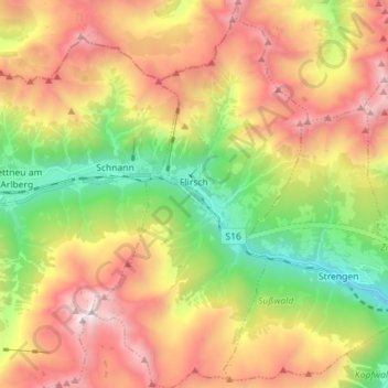
Name: Flirsch topographic map, elevation, terrain.
Location: Flirsch, Bezirk Landeck, 6572, Österreich (47.09725 10.37105 47.19378 10.45049)
Average elevation: 1,980 m
Minimum elevation: 967 m
Maximum elevation: 3,135 m
Thank you for supporting this site ❤️
Make a donation
Make a donation
Other topographic maps
Click on a map to view its topography, its elevation and its terrain.
Thank you for supporting this site ❤️
Make a donation
Make a donation
Parseierspitze
Österreich > Bezirk Landeck > Grins
Die Parseierspitze ist mit einer Höhe von 3036 m ü. A. der höchste Gipfel der nördlichen Kalkalpen und deren einziger Dreitausender. Die im österreichischen Bundesland Tirol gelegene Spitze ist der Hauptgipfel der Lechtaler Alpen. Erstmals bestiegen wurde sie am 23. August 1869 von Josef Anton Specht und…
Average elevation: 2,414 m
Thank you for supporting this site ❤️
Make a donation
Make a donation