
Thank you for supporting this site ❤️
Make a donation
Make a donation
Rismyrliden topographic map
Click on the map to display elevation.
Thank you for supporting this site ❤️
Make a donation
Make a donation
About this map
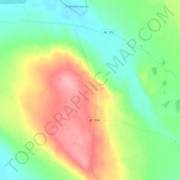
Name: Rismyrliden topographic map, elevation, terrain.
Location: Rismyrliden, Vilhelmina kommun, Västerbotten County, Sweden (64.48811 17.28490 64.52811 17.32490)
Average elevation: 441 m
Minimum elevation: 393 m
Maximum elevation: 510 m
Thank you for supporting this site ❤️
Make a donation
Make a donation
Other topographic maps
Click on a map to view its topography, its elevation and its terrain.
Thank you for supporting this site ❤️
Make a donation
Make a donation
Thank you for supporting this site ❤️
Make a donation
Make a donation
Thank you for supporting this site ❤️
Make a donation
Make a donation
Thank you for supporting this site ❤️
Make a donation
Make a donation
Thank you for supporting this site ❤️
Make a donation
Make a donation