
Izu topographic map
Interactive map
Click on the map to display elevation.
About this map
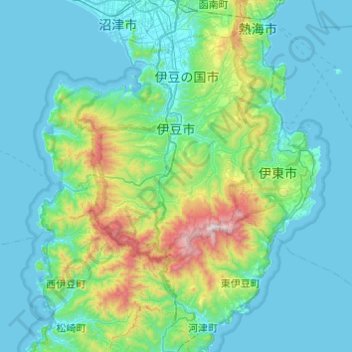
Name: Izu topographic map, elevation, terrain.
Location: Izu, Shizuoka Prefecture, Japan (34.82638 138.58345 35.01619 139.06883)
Average elevation: 209 m
Minimum elevation: 0 m
Maximum elevation: 1,367 m
Other topographic maps
Click on a map to view its topography, its elevation and its terrain.
Kanto
Japan > Shizuoka Prefecture > Shizuoka > 筑摩
Kanto, 山脇大谷線, 十二双団地, Aoi Ward, Shizuoka, Shizuoka Prefecture, 420-0804, Japan
Average elevation: 29 m