
Thank you for supporting this site ❤️
Make a donation
Make a donation
Winthrop topographic map
Click on the map to display elevation.
Thank you for supporting this site ❤️
Make a donation
Make a donation
About this map
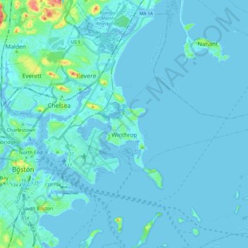
Name: Winthrop topographic map, elevation, terrain.
Average elevation: 5 m
Minimum elevation: -3 m
Maximum elevation: 70 m
Thank you for supporting this site ❤️
Make a donation
Make a donation
Other topographic maps
Click on a map to view its topography, its elevation and its terrain.
Boston
United States > Massachusetts > Suffolk County > Boston
Boston has an area of 89.63 square miles (232.1 km2)—48.4 square miles (125.4 km2) (54%) of land and 41.2 square miles (106.7 km2) (46%) of water. The city's official elevation, as measured at Logan International Airport, is 19 ft (5.8 m) above sea level. The highest point in Boston is Bellevue Hill at 330…
Average elevation: 26 m