
Make a donation
Bridport topographic map
Click on the map to display elevation.
Make a donation
Bridport
Bridport is in the county of Dorset in South West England. Measured directly, it is about 14 miles (23 km) west of the county town Dorchester, 15.5 miles (25 km) SSW of Yeovil in Somerset, 33 miles (53 km) east of Exeter in Devon and 1.5 miles (2.4 km) inland from the English Channel at West Bay. The town centre is sited between the small River Brit and its tributary the Asker, about 0.5 miles (0.8 km) north of their confluence, at an altitude of 10–15 metres (33–49 ft). Another small tributary, the River Simene, also joins the Brit to the west of the town centre.
Make a donation
About this map
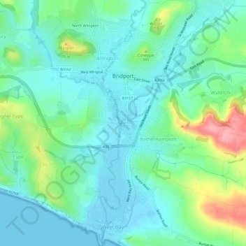
Name: Bridport topographic map, elevation, terrain.
Location: Bridport, Dorset, England, United Kingdom (50.70846 -2.77110 50.74499 -2.73756)
Average elevation: 32 m
Minimum elevation: -3 m
Maximum elevation: 128 m
Make a donation
Other topographic maps
Click on a map to view its topography, its elevation and its terrain.
Make a donation
Make a donation