
Thank you for supporting this site ❤️
Make a donation
Make a donation
Kastelruth - Castelrotto topographic map
Click on the map to display elevation.
Thank you for supporting this site ❤️
Make a donation
Make a donation
About this map
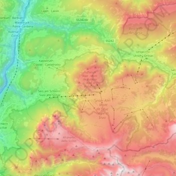
Name: Kastelruth - Castelrotto topographic map, elevation, terrain.
Average elevation: 1,561 m
Minimum elevation: 401 m
Maximum elevation: 2,863 m
Thank you for supporting this site ❤️
Make a donation
Make a donation
Other topographic maps
Click on a map to view its topography, its elevation and its terrain.
Ellen - Elle
Italy > Trentino-Alto Adige/Südtirol > South Tyrol > St. Lorenzen - San Lorenzo di Sebato
Average elevation: 1,348 m
Pineta - Steinmannwald
Italy > Trentino-Alto Adige/Südtirol > South Tyrol > Laives - Leifers
Average elevation: 549 m
Pawigl - Pavicolo
Italy > Trentino-Alto Adige/Südtirol > South Tyrol > Lana
Average elevation: 1,185 m